18 Attractions to Explore Near Eremo di San Domenico (Prato Cardoso)
Top Activities Near Eremo di San Domenico (Prato Cardoso)
Filter By Date
//
Sort By

Attractions & Activities Near You
Checkout attractions and activities near your current locationAll attractions near Eremo di San Domenico (Prato Cardoso)
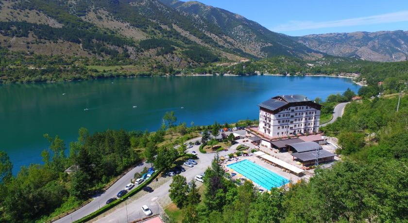
Lago di San DomenicoThe lake of San Domenico is a mountain lake, located in the municipality of Villalago, in the province of L'Aquila, near the hermitage of San Domenico. The main tributary is the Sagittario, which is also the river that flows from the dam that creates the lake; the lake is also endowed with tributaries of minimal importance such as the waterfalls of the Sega spring and the small stream of Prato Cardoso which enters the lake in karst conditions
Lago di ScannoLago di Scanno is a beautiful lake in the Province of L'Aquila, Abruzzo. One of the best places to relax and it was located in the center of mountains which was covered by greenery and it is a good location for trekking and also for swimming.
Lake of ScannoThe Lake Scanno is a lake mountain, located in Abruzzo, belonging to about 3/4 of its surface to the territory of the municipality of Villalago and about 1/4 that of Scanno. The lake is good for public use of the two municipalities mentioned. It originated from an ancient landslide that broke off from Mount Genzana above which blocked the river Tasso in a period between 12,820 and 3,000 years ago.
Riserva Naturale Regionale Monte Genzana e Alto GizioThe guided nature reserve Monte Genzana and Alto Gizio is a protected natural area located in the municipality of Pettorano sul Gizio , in the province of L'Aquila, and was established in 1996. It includes an area of about 3,160 hectares it is possible to observe the mountains of the Abruzzo National Park to the west and the Majella to the east, the underlying Lake Scanno to the west, and the Cinquemiglia plateau to the south. The park acts as a buffer between the Abruzzo, Lazio and Molise N
National Park of AbruzzoA majestic national park which has an area of 50.000 hectares, with about 80.000 hectares of the buffer zone. The scenery here is characterized by mountain chains, karst phenomena, rivers (including the Sangro River), and streams and its rich flora and fauna increase the beauty of this national park.
PescasseroliPescasseroli is an Italian town of 2 126 inhabitants in the province of L'Aquila in Abruzzo. It is the seat of the managing body of the Abruzzo, Lazio, and Molise national park. From the historical point of view, the territory had particular influences of the Marsi and Peligni . Included in the county of Marsi until the High Middle Ages, followed from the Low Middle Ages onwards, the historical and cultural vicissitudes of the Alto Sangro territory. A summer and winter resort, it is also the lo
Altopiano delle CinquemigliaThe Cinquemiglia plateau was a mountain community comprising the upper valley of the Sangro river and the Maggiore plateau. The territory of the mountain community was largely included in the national park of Abruzzo, Lazio and Molise. It also included the major ski resorts in central- southern Italy : Pescocostanzo , Rivisondoliand Roccaraso , which was later added to that of Pescasseroli.
Monte MarsicanoMount Marsicano is one of the peaks greater than Marsicani mountains, high 2.245 m s.lm , located in the protected national park of Abruzzo, Lazio and Molise , between the municipalities of Opi, Pescasseroli, Scanno and Barrea. Nestled between the valleys of the Marsicani mountains, it forms a real mountain group which together with the Montagna Grande group and the Serra della Terratta gives life in turn to a long mountain ridge that divides the Pescasseroli - Opi.
Valle PelignaThe Valle Peligna, also known as Conca di Sulmona, is a plateau in central Abruzzo, southern Italy, included in the province of L'Aquila. It has a surface of some 100 km². The valley is crossed by the rivers Aterno and Sagittario. In addition to Sulmona, the main centers in the plateau include Raiano, Vittorito, Corfinio, Pratola Peligna and Pacentro.
Bosco di Sant'AntonioThe Bosco di Sant'Antonio nature reserve is a protected natural area located in the municipality of Pescocostanzo, in the province of L'Aquila. It was established in 1986 and since 1992 is part of the Majella National Park and stretches for 550 ha between the ridges of Monte Pizzalto and Monte Rotella. Immersed in numerous centuries-old beech trees, it houses the hermitage of Sant'Antonio. Due to its characteristics, it is an ideal place for horse riding, hiking and cross-country skiing.
Santuario di Santa Maria di Monte TranquilloThe sanctuary of Santa Maria di Monte Tranquillo is a place of worship located in the municipality of Pescasseroli in Abruzzo. The original building of worship, called the church of Santa Maria in Tranquillo or of Santa Maria Della Serra, was probably built in the early 12th century by the will of the bishop of the Marsi, San Berardo who intended to build churches in the mountain passes of the Marsica offer refuge to the faithful and travelers.
Abbazia di Santo Spirito del MorroneThe Abbazia di Santo Spirito del Morrone is a former monastery some five kilometers outside of the town of Sulmona, at the base of Monte Morrone, in the Province of L'Aquila, region of Abruzzo, Italy. This was the main abbey of the Celestine order, a Benedictine order offshoot. By the 19th century, the abbey was deconsecrated, functioning more recently as a prison. In the last decades, restoration has proceeded and it now serves as a Museum.
Hermitage of Saint VenantiusThe Hermitage of San Venanzio is the site the ancient hermitage of Saint Venantius of Camerino, located above a stream in a remote ravine within a few kilometers north of Raiano, Province of L'Aquila in the Abruzzo, Italy. One of the ancient pilgrimage sites in this area which was also a important site till today.
The Natural Reserve CamosciaraThe integral nature reserve of Camosciara, commonly known as Camosciara, is a protected natural area located in the municipalities of Civitella Alfedena , Opi and Pescasseroli, in the province of L'Aquila, which represents the original and central nucleus of the national park of Abruzzo, Lazio and Molise. The crown of mountains surrounding the integral nature reserve is made up of limestone rocks and dolomites that give it a dolomitic appearance
Monte GrecoThe Monte Greek is the highest peak of the group Marsicani Monti, in ' Abruzzese Apennines, located on the edge of the Parco Nazionale d'Abruzzo, within the territory of municipalities of Barrea and Roccaraso. It forms a real mountainous group that divides the Alto Sangro area to the west from that of the major highlands of Abruzzo to the east. Among the most popular routes, the ascent from the road that connects Villetta Barrea to Passo Godi , through a dense beech forest and then, above 1900 m
Cascata delle NinfeThe waterfall of the Ninfe is part of a series of waterfalls of the Scerto stream, including the waterfall of the Tre Cannelle, which are located within the National Park of Abruzzo, Lazio, and Molise, in the integral nature reserve of Camosciara, among the municipalities of Civitella Alfedena and Pescasseroli. The waterfall is deeply embedded in the rocks due to the waters of the Scerto stream, which have a slight degree of acidity, and which flow on a bed of Dolomite rocks.
Piano AremognaThe Piano Aremogna is a highland mountain of ' Abruzzo Southern, located in the municipality of Roccaraso, the lower the province at an altitude of 1500-1600 m above sea level, surrounded to the west by the mountains of Roccaraso, subgroup of the massif of Monte Greek. Its importance derives from the fact that the ski lifts of the Roccaraso ski resort depart from it together with Pizzalto, included within the Alto Sangro ski area.
Passo San LeonardoPasso San Leonardo is a pass of the central Apennines, located in Abruzzo, in the western part of the Majella massif and south-east of the Morrone Mountains group, within the municipalities of Pacentro and Sant 'Eufemia a Maiella. Route from the state road 487, it connects Pacentro with Sant'Eufemia a Maiella, with the possibility of reaching Campo di Giove through the provincial road 54.
Map of attractions near Eremo di San Domenico (Prato Cardoso)
Top hotels near Eremo di San Domenico (Prato Cardoso)
20 Reviews
5.6
$85.21 per nightSelect
Know more about Eremo di San Domenico (Prato Cardoso)
Eremo di San Domenico (Prato Cardoso)The hermitage of San Domenico is a small church, located in the territory of the municipality of Villalago, in the Sagittario valley, on the shore of the homonymous Lake of San Domenico. It includes a cave dug into the limestone, in which according to tradition, around the year 1000 the Benedictine monk San Domenico lived.